Hookito

The Hookito atlas

Travel maps: road, plug, phone and clock clues

All world maps →

What changes when you cross a border: the side of the road, plugs and voltage, phone codes, emergency numbers, web domains, writing systems, time zones, date order, the start of the week and where tourists go. Handy for travel and for guessing where a photo was taken.

About these maps

The collection brings together data Hookito already uses: the capitals and facts behind the country pages, the outlines from the countries list, the paintings in Art, the album lists in Audio and the night side of the globe. The boundaries combine Eurostat GISCO and Natural Earth data. The world maps use a plain equirectangular projection, cropped at 84° north and 58° south; the continent and Europe maps are zoomed from more detailed boundaries.

Spotted a mistake? Write to submissions@hookito.com.

9 maps

Travel

Driving sides, plugs, voltage, phone codes, emergency numbers, web domains and scripts: what changes when you cross a border.

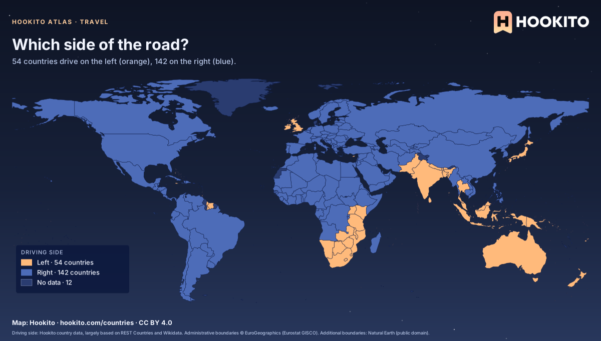
Which side of the road?

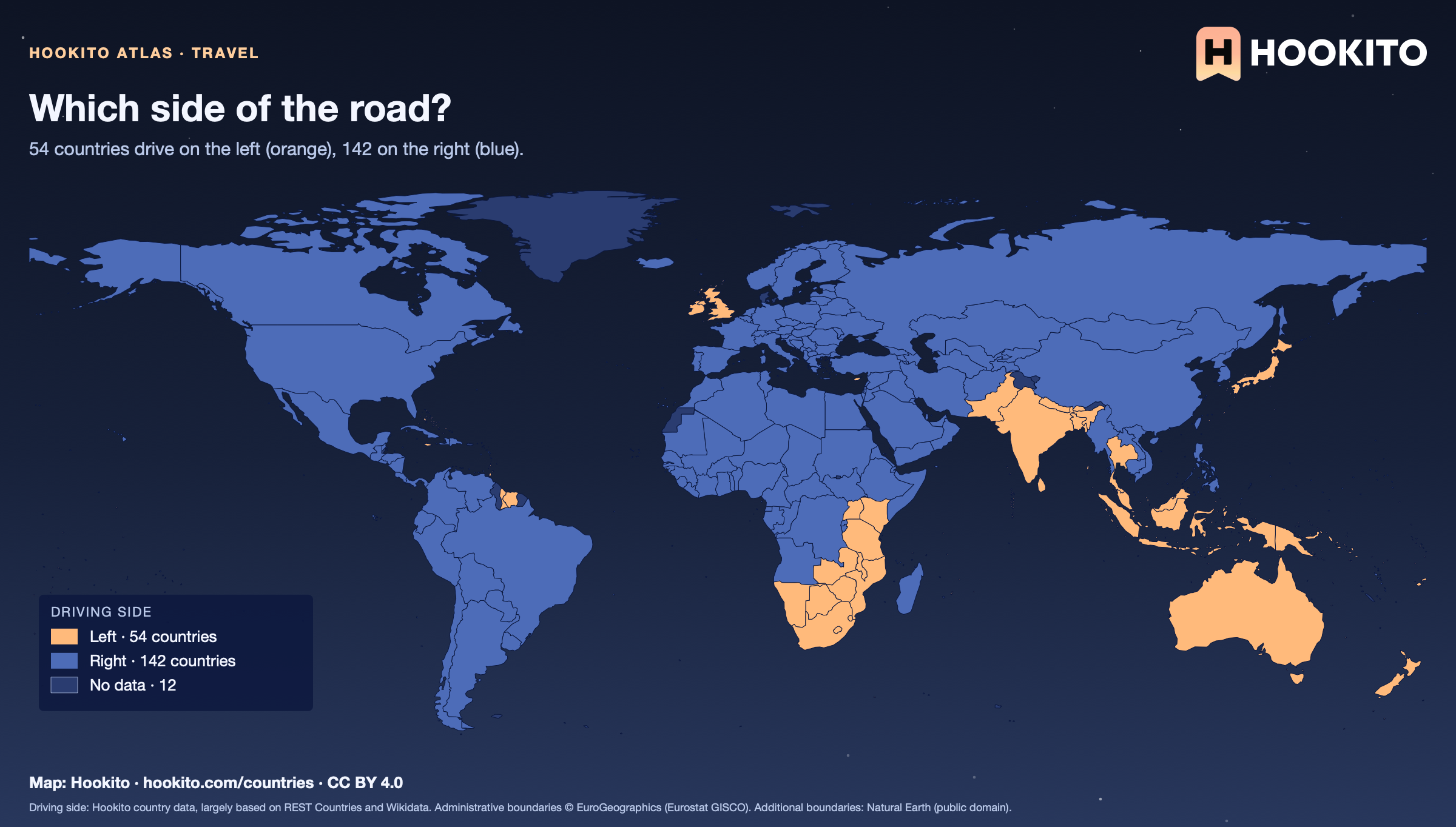
World map: 54 countries that drive on the left in orange, including the UK, India, Japan and Australia, and 142 that drive on the right in blue.

The left side survives mostly where the British Empire left its mark, plus Japan and Thailand. Where a country has no value in the data it stays grey: 12 of 208.

Embed this map

Driving side: Hookito country data, largely based on REST Countries and Wikidata. Administrative boundaries © EuroGeographics (Eurostat GISCO). Additional boundaries: Natural Earth (public domain).

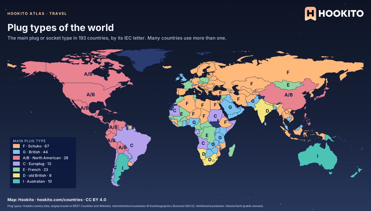
Plug types of the world

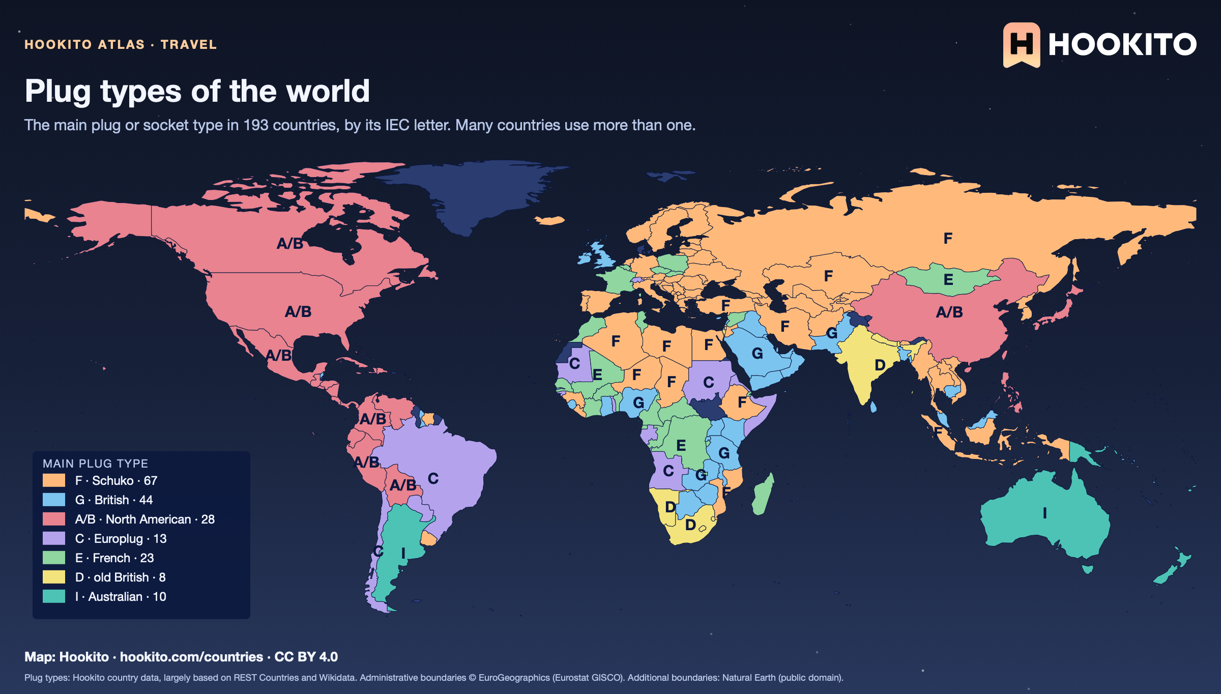
World map shading countries by their main plug type: F (Schuko) and C across Europe, G in the UK and much of Africa and Asia, A/B in the Americas, I in Australia.

Type F leads with 67 countries. Where a country lists several types, the one most countries use is shown. The Europlug (C) only wins where nothing else is listed. Check the country page before you pack an adapter.

Embed this map

Plug types: Hookito country data, largely based on REST Countries and Wikidata. Administrative boundaries © EuroGeographics (Eurostat GISCO). Additional boundaries: Natural Earth (public domain).

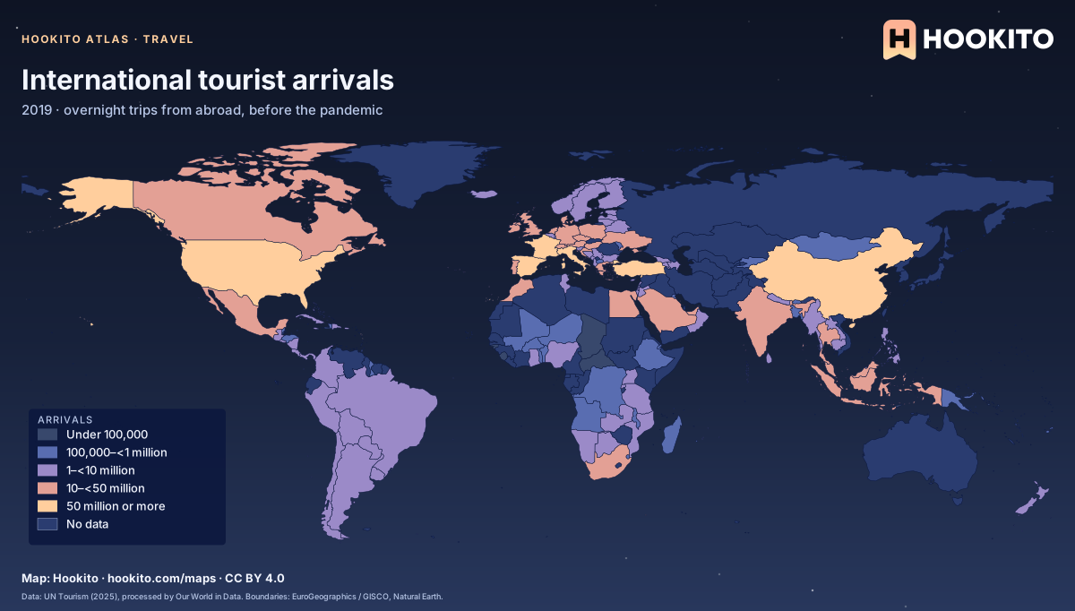
International tourist arrivals

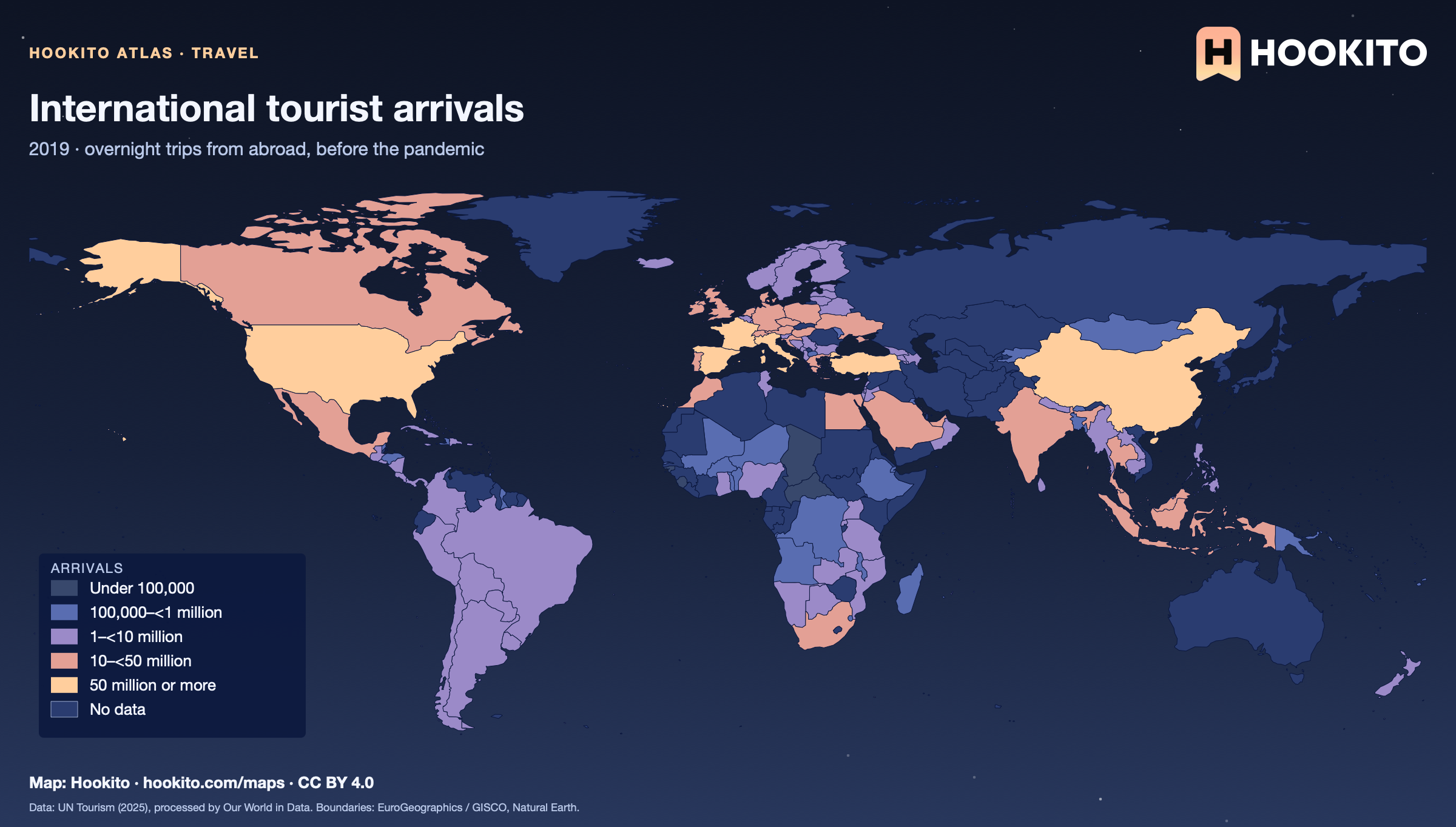
International tourist arrivals, world map with five colour bands and missing data.

Arrivals count trips, not unique people. Figures are for 2019, a comparable pre-pandemic baseline. Grey-blue indicates no data. Source details and reuse terms: https://ourworldindata.org/grapher/international-tourist-trips.

Embed this map

Data: UN Tourism (2025), via Our World in Data (https://ourworldindata.org/grapher/international-tourist-trips). Administrative boundaries © EuroGeographics (Eurostat GISCO). Additional boundaries: Natural Earth (public domain). Source data and citation ↗

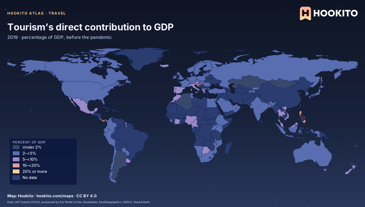
Tourism’s direct contribution to GDP

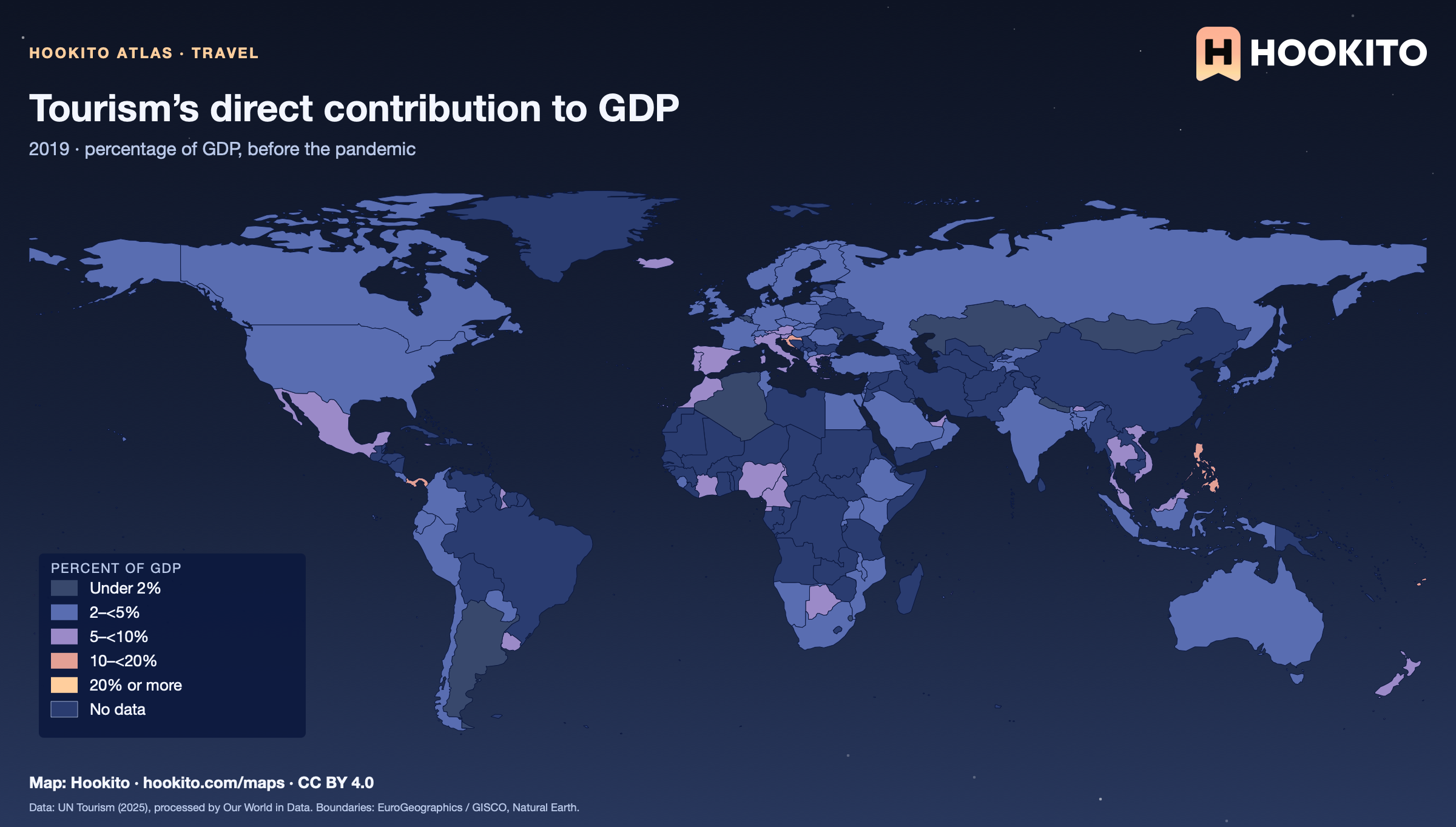
Tourism’s direct contribution to GDP, world map with five colour bands and missing data.

Share of GDP directly attributable to tourism. Figures are for 2019, a comparable pre-pandemic baseline. Grey-blue indicates no data. Source details and reuse terms: https://ourworldindata.org/grapher/tourism-gdp-proportion-of-total-gdp.

Embed this map

Data: UN Tourism (2025), via Our World in Data (https://ourworldindata.org/grapher/tourism-gdp-proportion-of-total-gdp). Administrative boundaries © EuroGeographics (Eurostat GISCO). Additional boundaries: Natural Earth (public domain). Source data and citation ↗

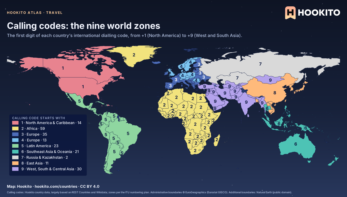
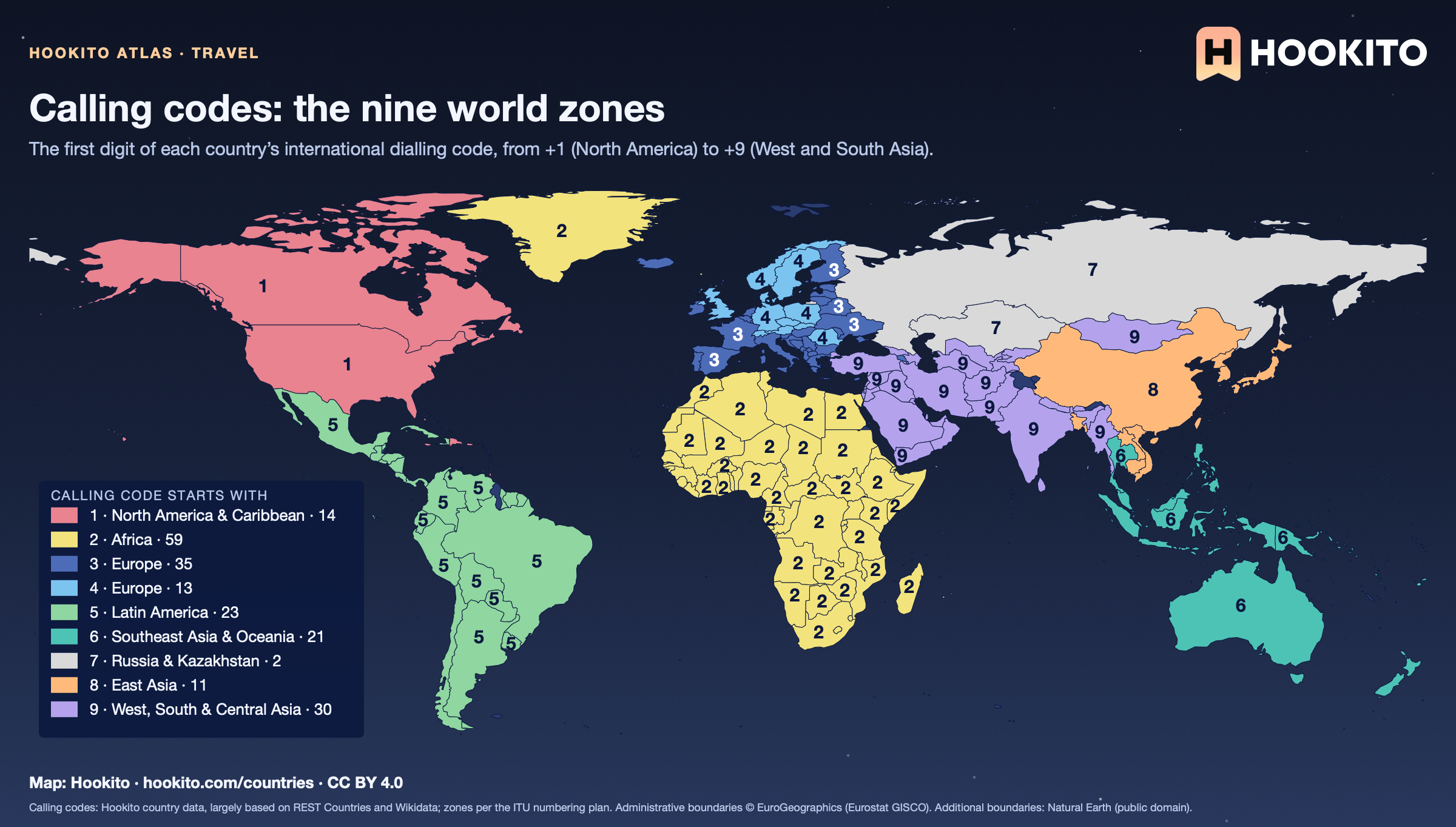
Calling codes: the nine world zones

World map of the first digit of international calling codes: 1 in the US, Canada and the Caribbean, 2 across Africa, 3 and 4 in Europe, 5 in Latin America, 6 in Southeast Asia and Oceania, 7 in Russia and Kazakhstan, 8 in East Asia and 9 from Turkey to India.

The zones follow geography with a few surprises: Bangladesh (+880), Cambodia (+855) and Laos (+856) are in zone 8, Myanmar (+95) in zone 9, and Russia shares +7 with Kazakhstan. Turkey’s code is +90 and the Dominican Republic’s +1, corrected from the source data.

Embed this map

Calling codes: Hookito country data, largely based on REST Countries and Wikidata; zones per the ITU numbering plan. Administrative boundaries © EuroGeographics (Eurostat GISCO). Additional boundaries: Natural Earth (public domain).

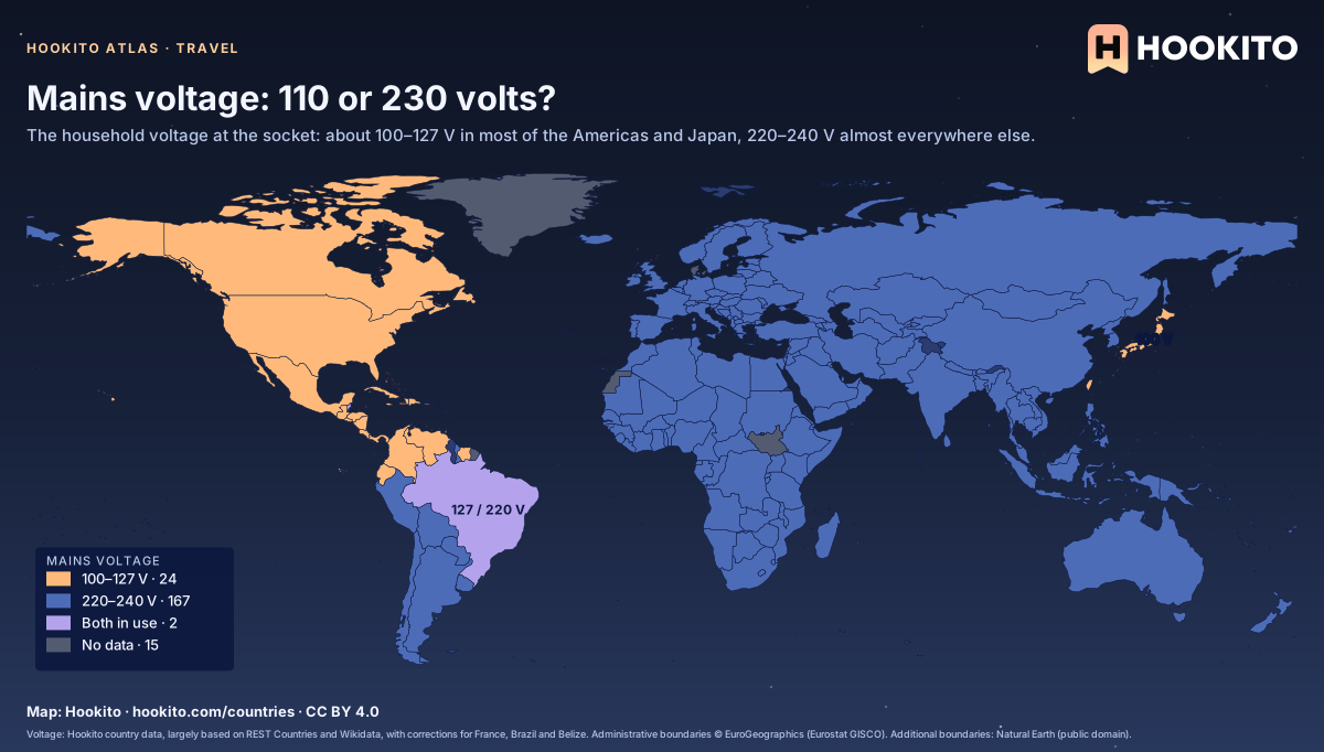
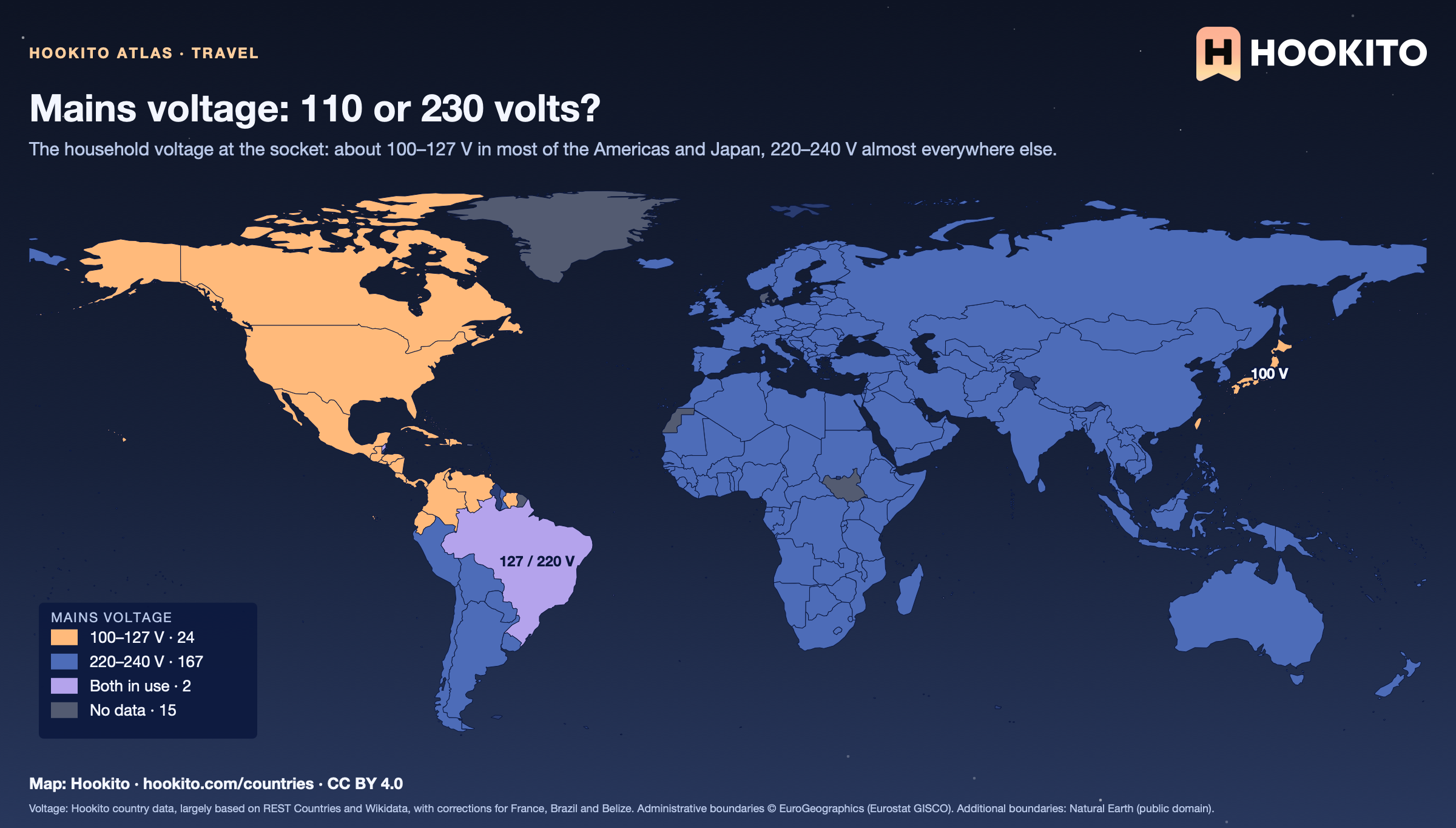
Mains voltage: 110 or 230 volts?

World map of mains voltage: the US, Canada, Mexico, Central America, parts of South America, Taiwan and Japan in orange (100–127 V), most of the world in blue (220–240 V), Brazil and Belize in purple (both).

Japan has the lowest, 100 V. Brazil and Belize use both voltages; France is corrected from 400 V (three-phase) to 230 V. A plug adapter does not change the voltage: check the label on your charger, most are rated 100–240 V. 15 places without a value stay grey.

Embed this map

Voltage: Hookito country data, largely based on REST Countries and Wikidata, with corrections for France, Brazil and Belize. Administrative boundaries © EuroGeographics (Eurostat GISCO). Additional boundaries: Natural Earth (public domain).

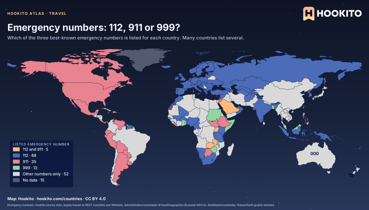
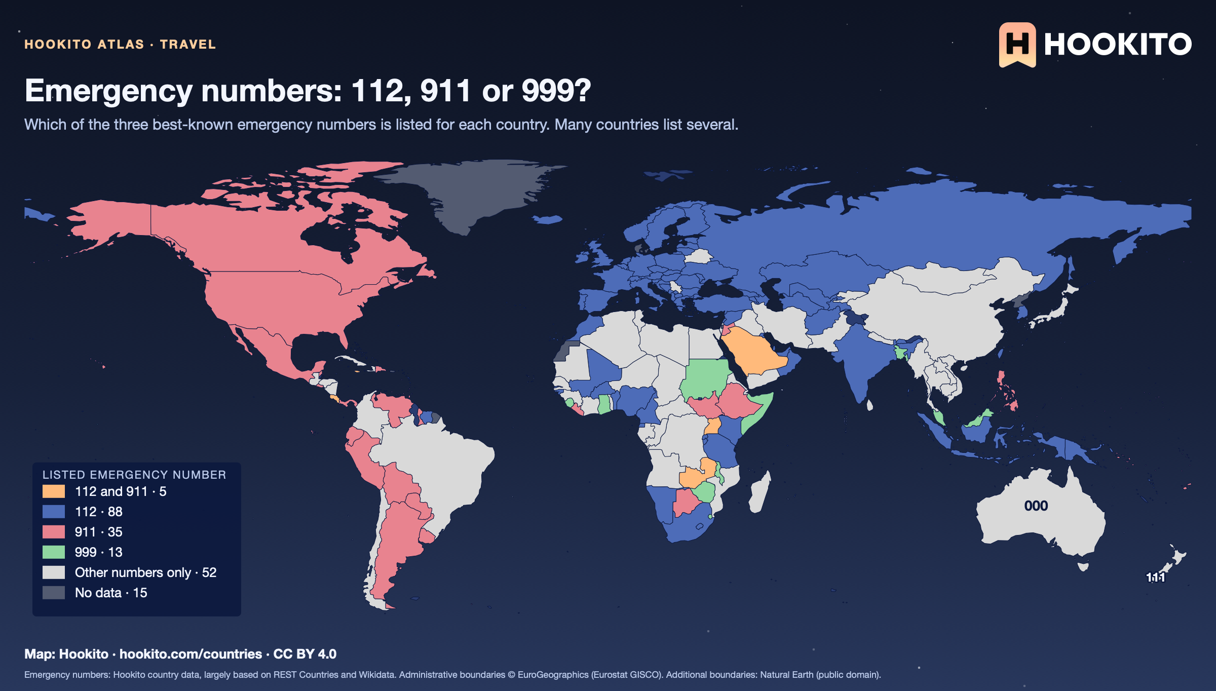
Emergency numbers: 112, 911 or 999?

World map of emergency numbers: 112 across Europe and parts of Africa and Asia, 911 in North America and much of Latin America, both in some countries, 999 in parts of Asia and Africa, and other numbers such as 000 in Australia and 110/119 in China and Japan.

A country is coloured by whether 112, 911 or 999 appear among its listed numbers; 19 countries outside the 999 class also list 999, among them the UK, Kenya and Qatar. Mobile phones often connect 112 or 911 even where they are not listed, but don’t rely on it: check the local number when you arrive.

Embed this map

Emergency numbers: Hookito country data, largely based on REST Countries and Wikidata. Administrative boundaries © EuroGeographics (Eurostat GISCO). Additional boundaries: Natural Earth (public domain).

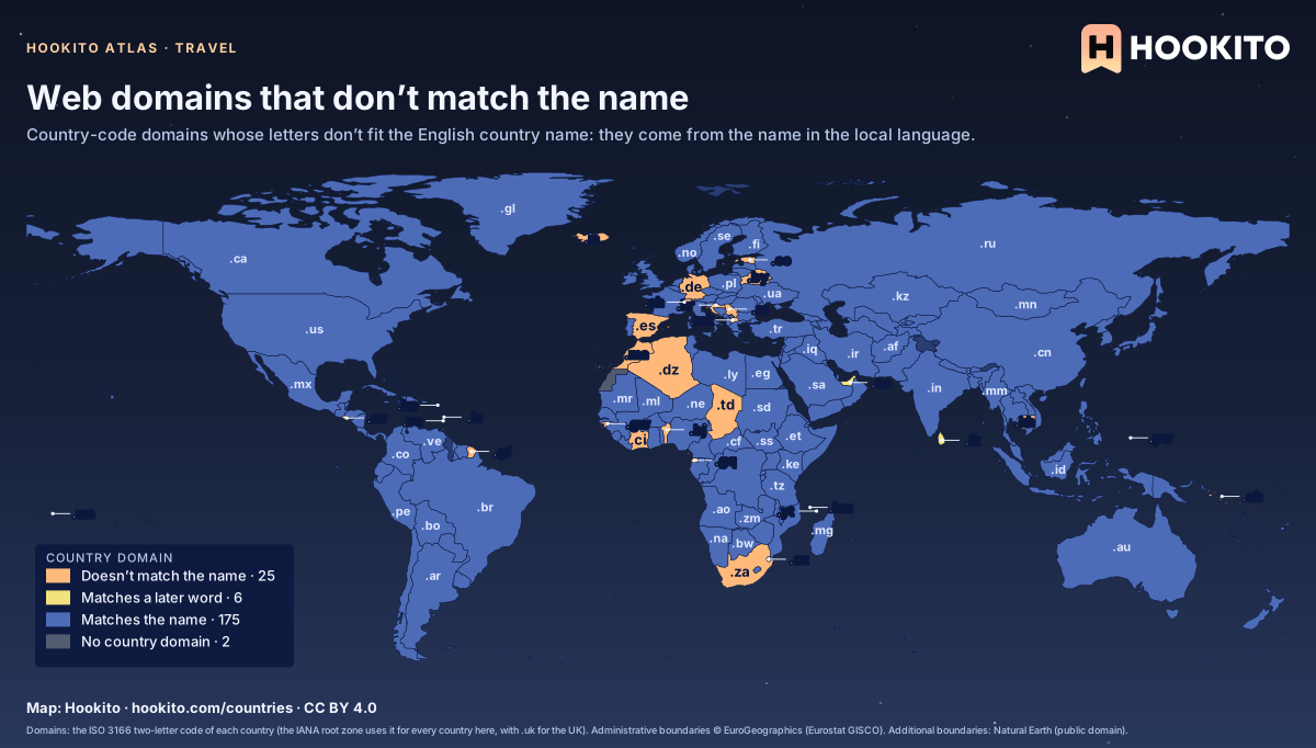
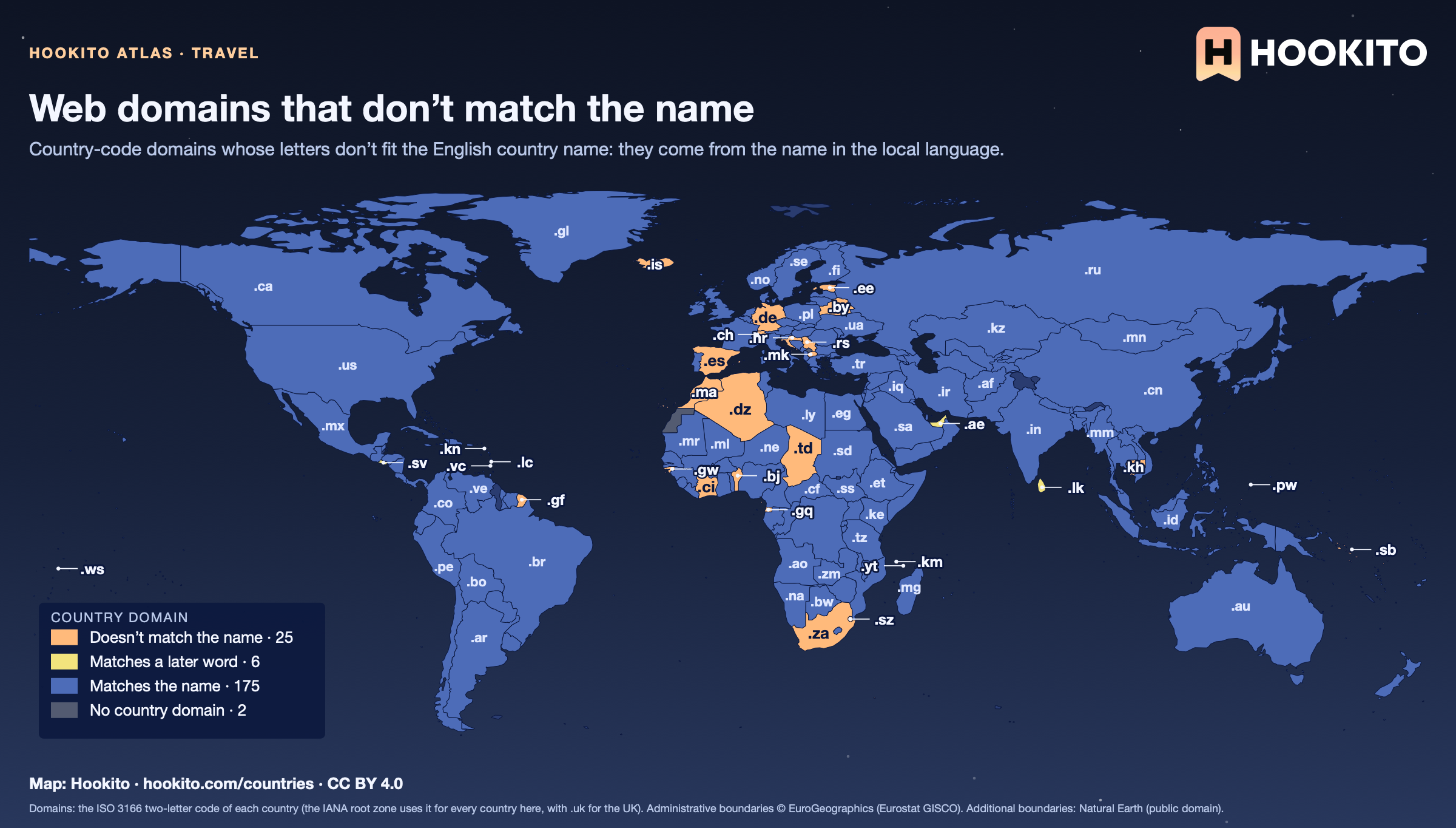
Web domains that don’t match the name

World map of country-code internet domains: 25 countries in orange whose domain doesn’t match the English name, such as .de for Germany, .ch for Switzerland, .es for Spain, .za for South Africa and .kh for Cambodia; partial matches like .lk for Sri Lanka in yellow; the rest in blue.

.de is from Deutschland, .ch from Confoederatio Helvetica, .es from España, .hr from Hrvatska and .za from Zuid-Afrika. The domain is the country’s two-letter ISO code in lower case, except .uk for the United Kingdom; Kosovo and Western Sahara have no country domain.

Embed this map

Domains: the ISO 3166 two-letter code of each country (the IANA root zone uses it for every country here, with .uk for the UK). Administrative boundaries © EuroGeographics (Eurostat GISCO). Additional boundaries: Natural Earth (public domain).

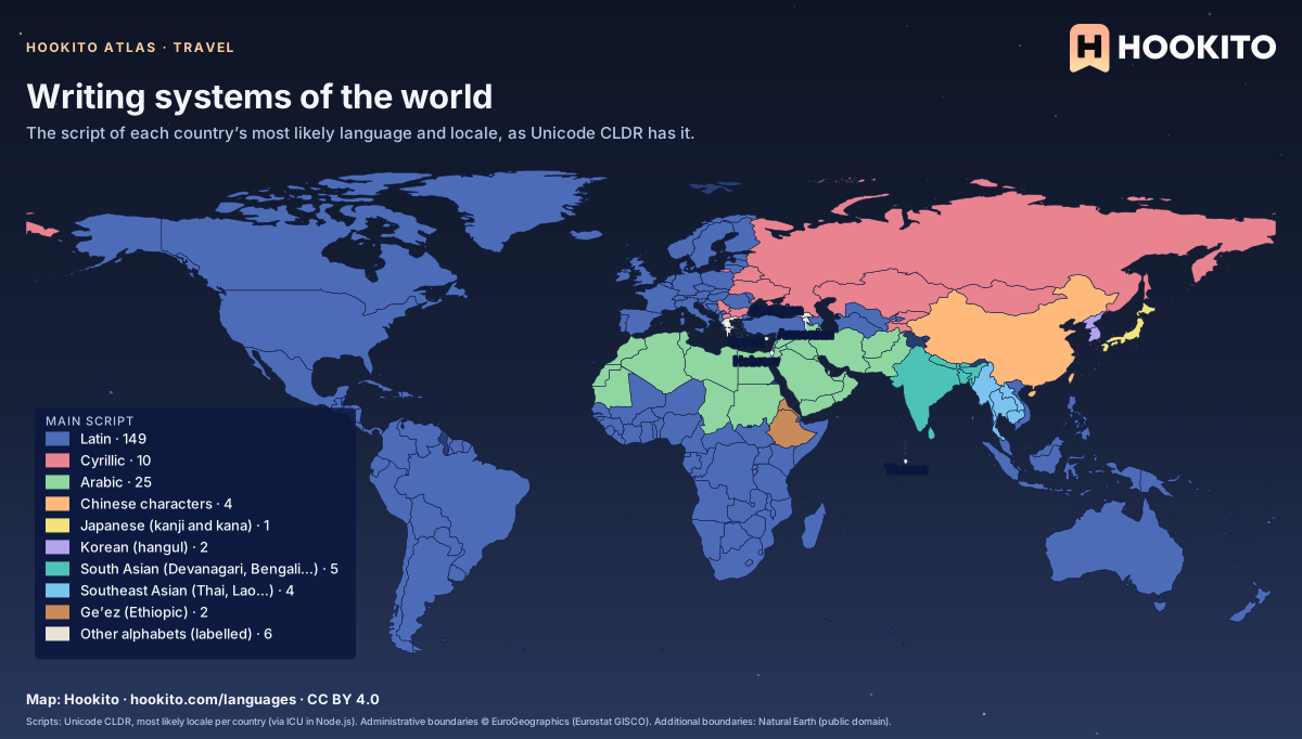
Writing systems of the world

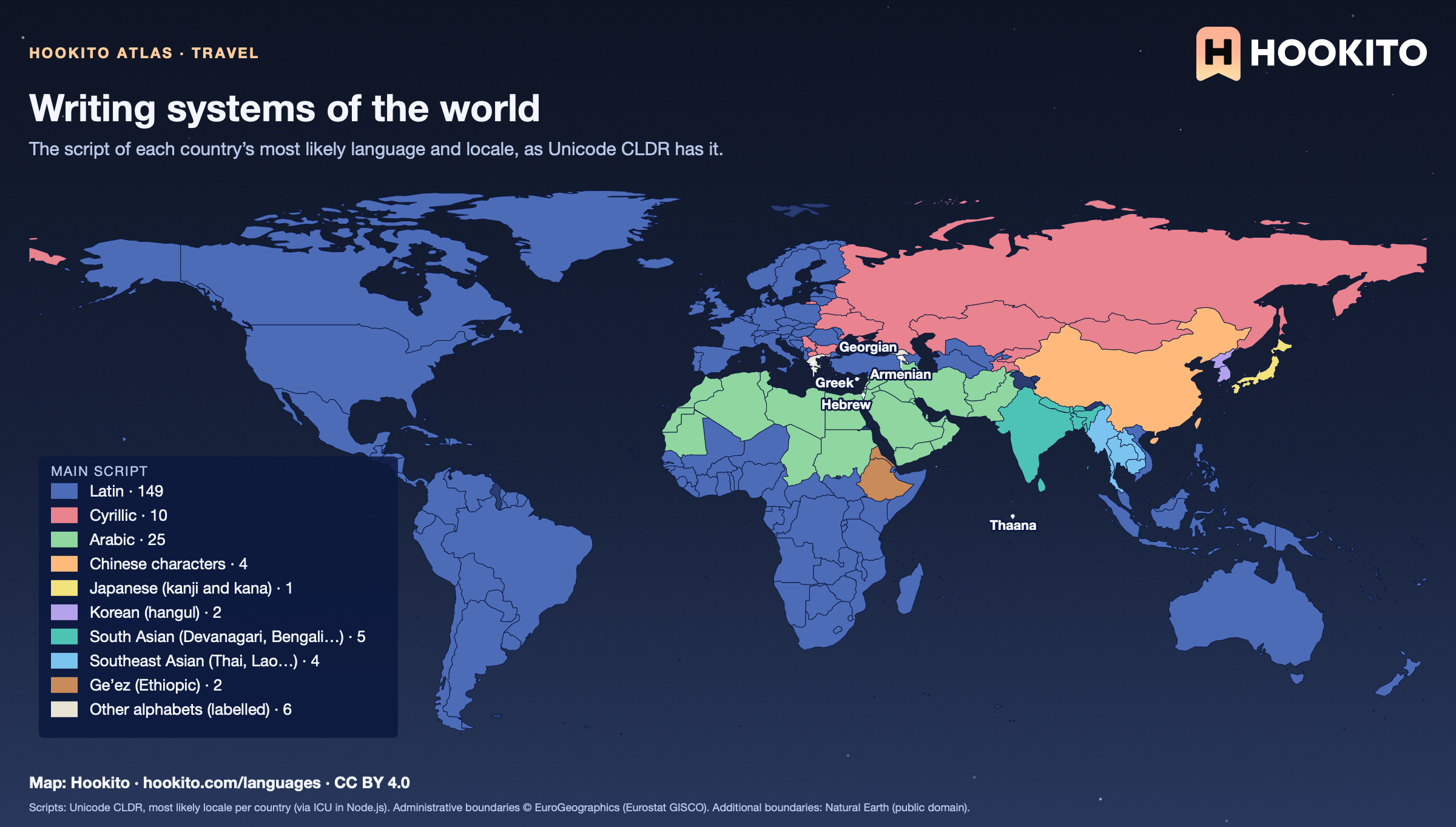
World map of the main writing system per country: Latin across the Americas, Europe, Africa and Oceania, Cyrillic from Serbia to Russia and Mongolia, Arabic from Morocco to Pakistan, Chinese characters in China and Taiwan, Japanese, Korean, South Asian scripts in India, Nepal, Bangladesh and Sri Lanka, Southeast Asian scripts in Thailand, Laos, Cambodia and Myanmar, Ge’ez in Ethiopia and Eritrea, and Greek, Hebrew, Georgian and Armenian labelled.

Each country shows the script of its most likely locale in CLDR, so many countries with more than one script get one: India (Devanagari for Hindi, also Latin and a dozen regional scripts), Serbia (Cyrillic, Latin is common too), Kazakhstan (Cyrillic, switching to Latin). South Sudan is shown in Latin script, where CLDR’s likely locale is Arabic, because English is its official language; Chad uses both Arabic and French.

Embed this map

Scripts: Unicode CLDR, most likely locale per country (via ICU in Node.js). Administrative boundaries © EuroGeographics (Eurostat GISCO). Additional boundaries: Natural Earth (public domain).

8 maps

Time & calendars

Time zones, clock changes, date order, the 12- or 24-hour clock and which day starts the week.

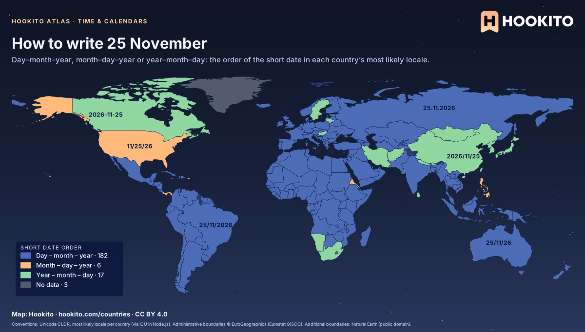
How to write 25 November

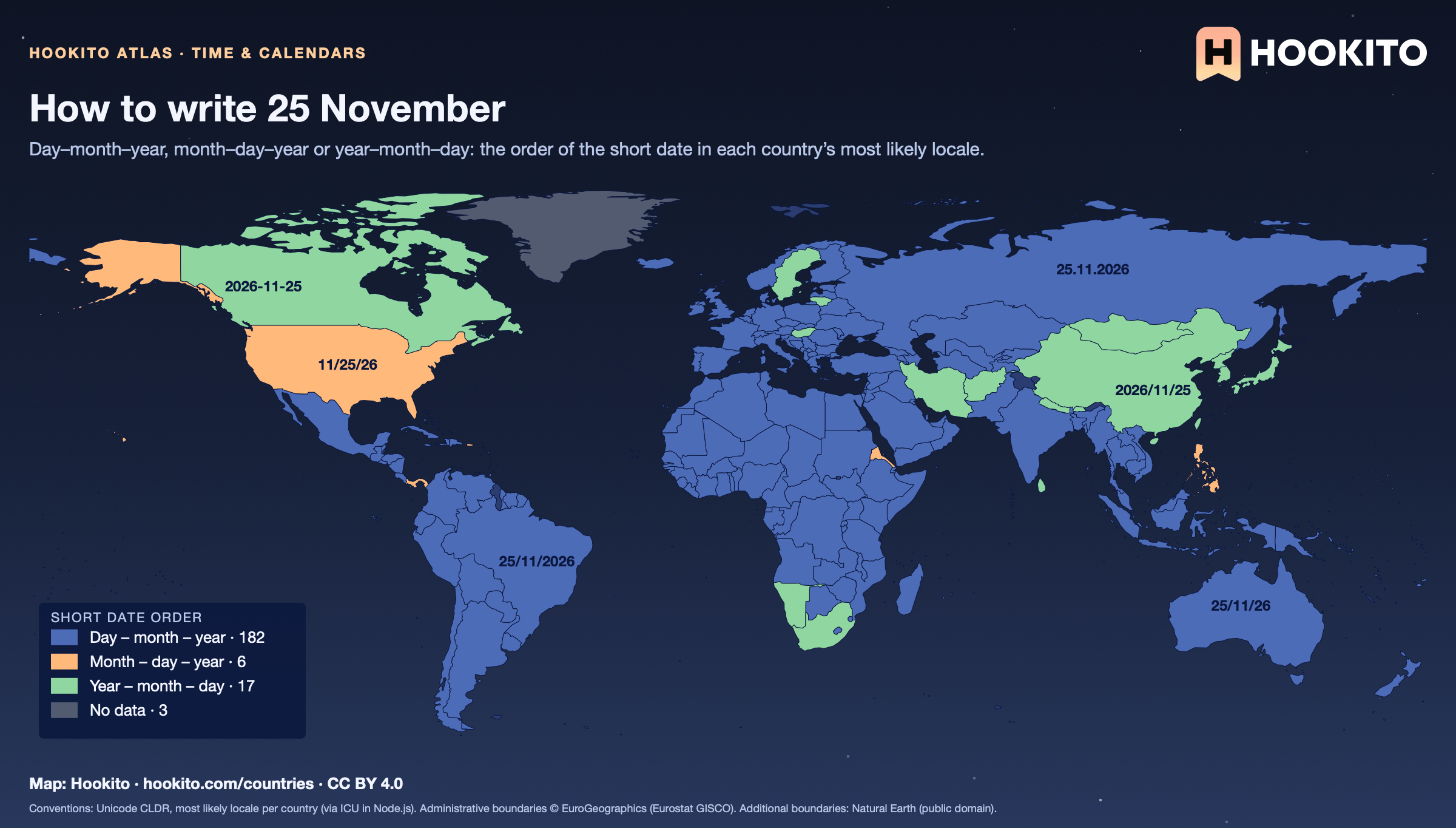
World map of date order: day-month-year in most of the world, month-day-year in the United States and a few other places, year-month-day in China, Japan, Korea, Iran, Hungary, Sweden and Lithuania among others.

Each country shows the short date of its most likely locale in CLDR; many countries write dates more than one way. Canada’s en-CA uses the ISO order 2026-11-25, though day-first and month-first are both common there, and Iran and Afghanistan count years in the Solar Hijri calendar. Where ICU has no data for the main language, an official co-language is used (French in Haiti, English in Ghana).

Embed this map

Conventions: Unicode CLDR, most likely locale per country (via ICU in Node.js). Administrative boundaries © EuroGeographics (Eurostat GISCO). Additional boundaries: Natural Earth (public domain).

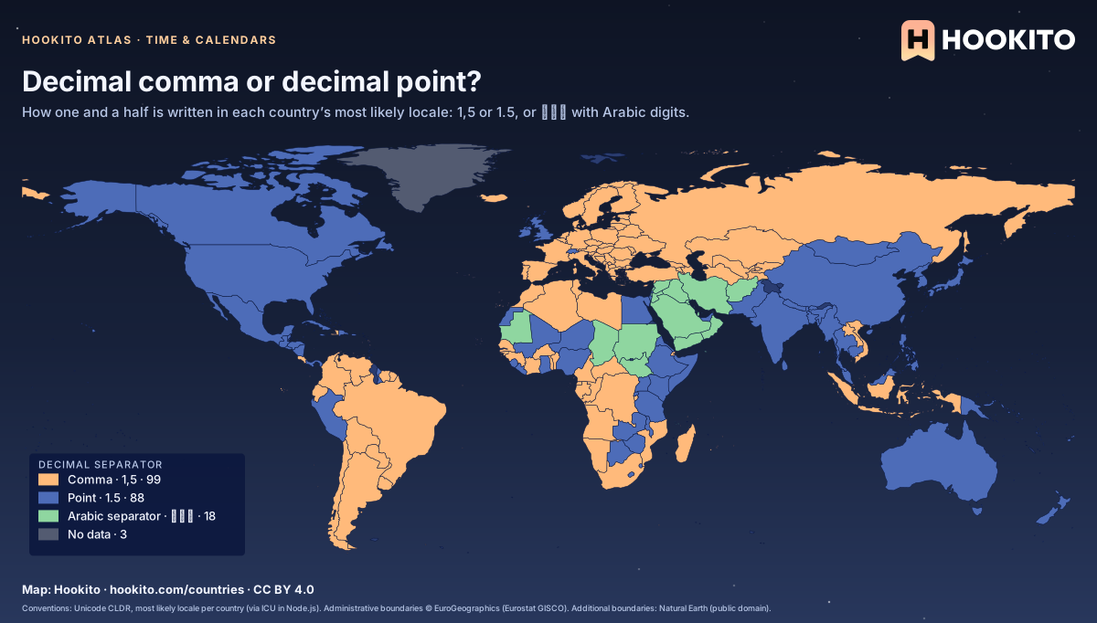
Decimal comma or decimal point?

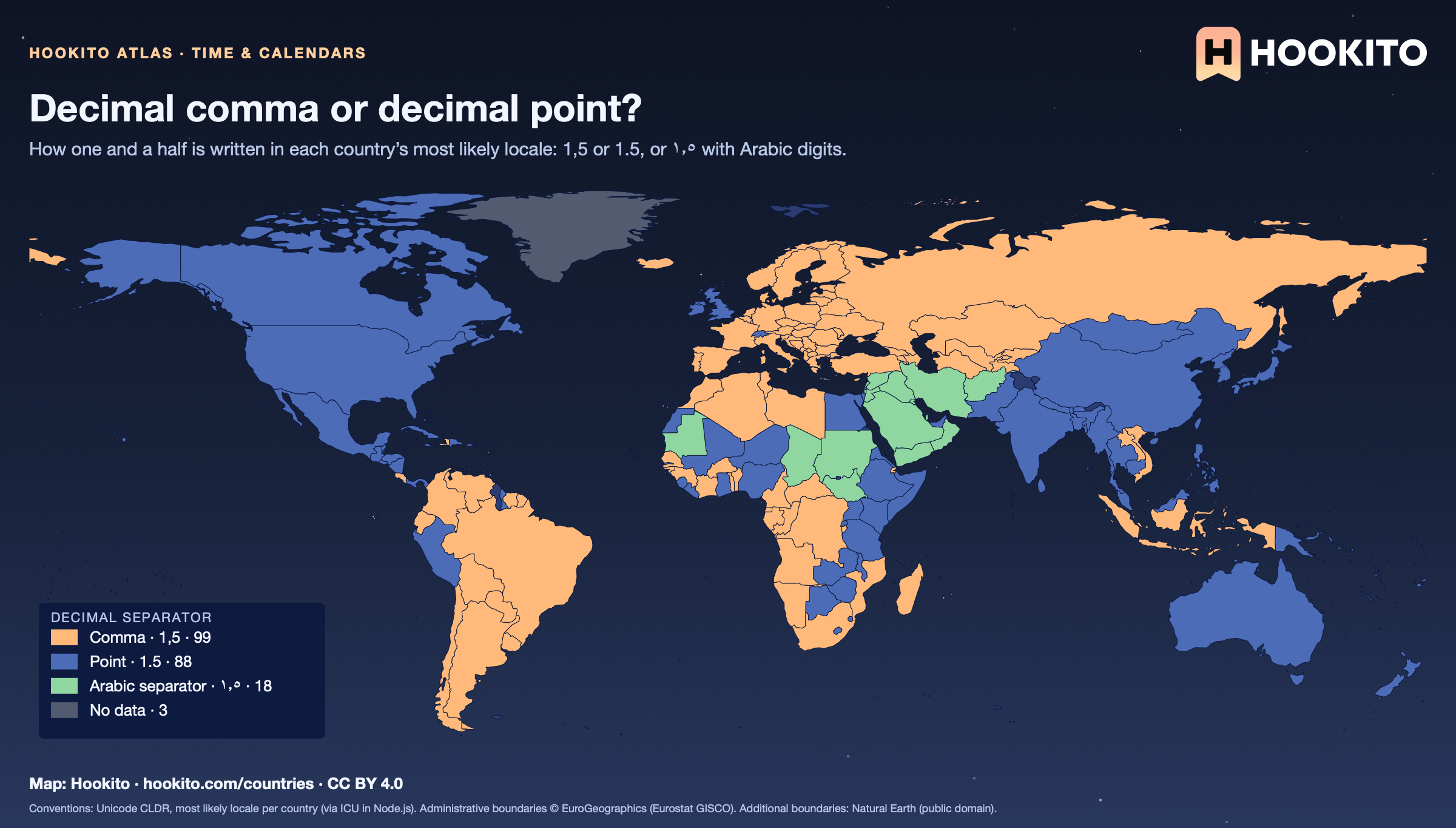
World map of decimal separators: the decimal comma across continental Europe, Latin America, Russia and much of Africa, the decimal point in the English-speaking world, China, Japan, India and Mexico, and the Arabic decimal separator in Iran, Afghanistan and several Arab countries.

Each country shows the separator of its most likely locale in CLDR; many countries use both, for example Canada (English and French) and Switzerland (a point in German Swiss usage, a comma in French). Locales written with Arabic-Indic digits use the Arabic decimal separator ٫; in CLDR, Egypt and the United Arab Emirates default to Western digits and a point, and the Maghreb to a comma.

Embed this map

Conventions: Unicode CLDR, most likely locale per country (via ICU in Node.js). Administrative boundaries © EuroGeographics (Eurostat GISCO). Additional boundaries: Natural Earth (public domain).

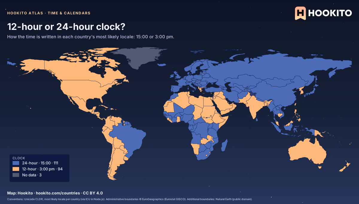
12-hour or 24-hour clock?

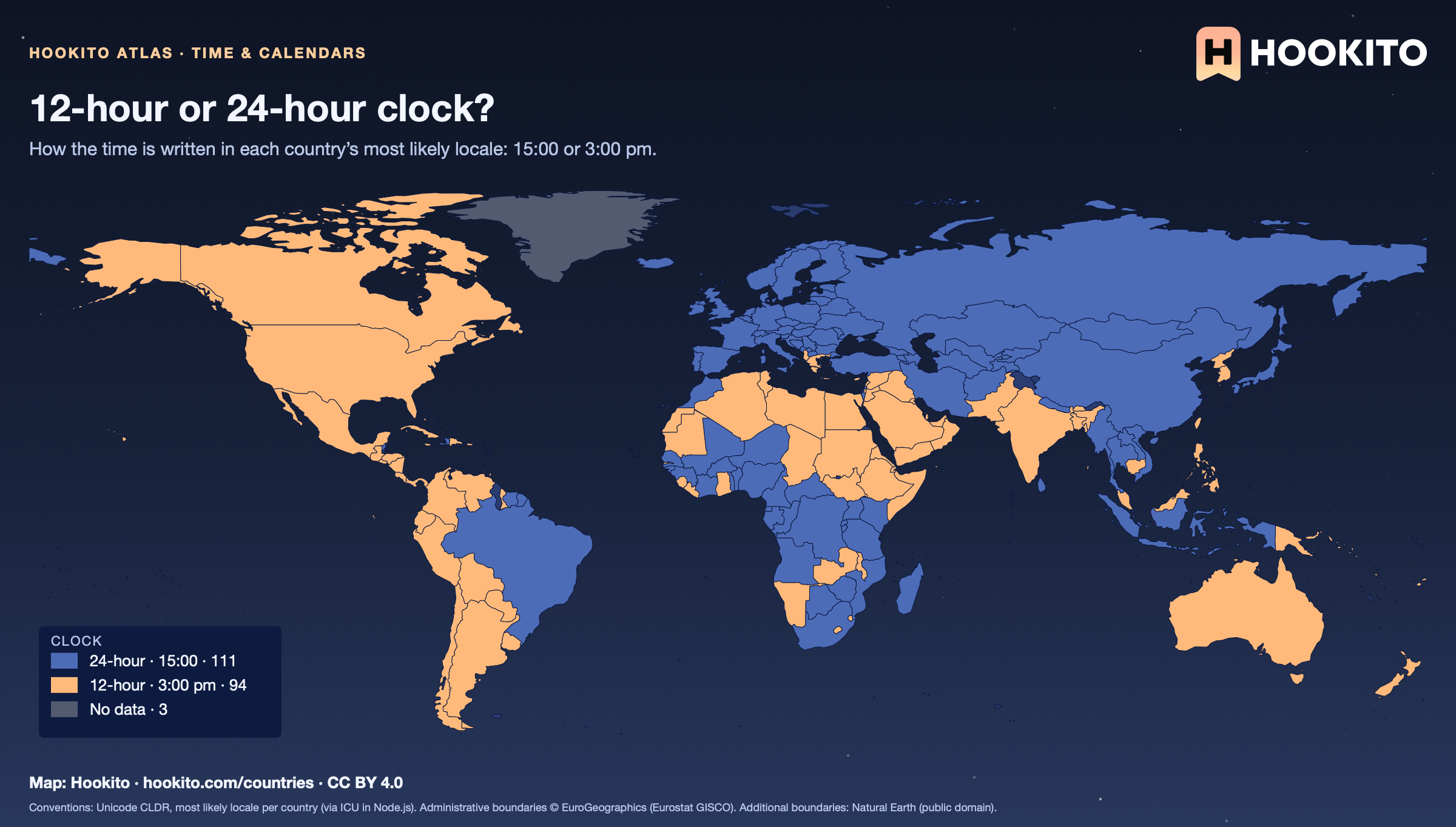
World map of clock formats: the 12-hour clock in the United States, Canada, most of Latin America, India, Pakistan, Australia, Egypt and the Arab Gulf, the 24-hour clock in Europe, Russia, China, Japan, Brazil and much of Africa.

Each country shows the short time format of its most likely locale in CLDR; spoken and written habits often differ, and many places use both. CLDR gives the 12-hour clock for most Spanish-speaking countries in the Americas and the 24-hour clock for Brazil; timetables almost everywhere use 24 hours.

Embed this map

Conventions: Unicode CLDR, most likely locale per country (via ICU in Node.js). Administrative boundaries © EuroGeographics (Eurostat GISCO). Additional boundaries: Natural Earth (public domain).

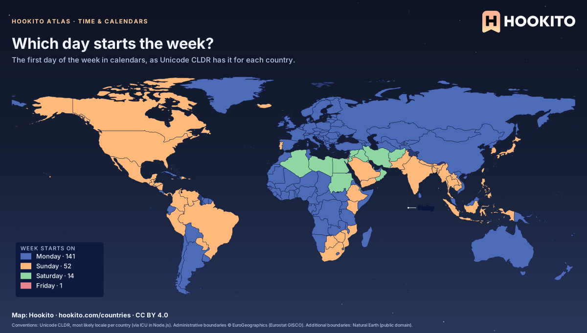
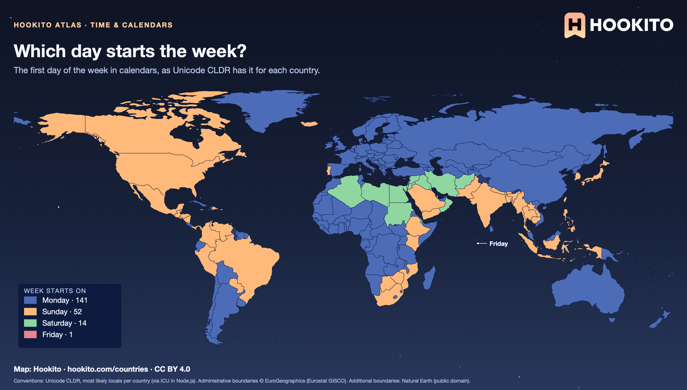
Which day starts the week?

World map of the first day of the week: Monday in Europe, Russia, China, Australia and much of Africa, Sunday in the Americas, Japan, India and southern Africa, Saturday in most of the Middle East and North Africa, and Friday in the Maldives.

This is the convention calendar apps use for each country in CLDR; ISO 8601 starts the week on Monday everywhere. Afghanistan, Egypt and Iran start on Saturday, the day after the Friday rest day, and CLDR has the Maldives start on Friday.

Embed this map

Conventions: Unicode CLDR, most likely locale per country (via ICU in Node.js). Administrative boundaries © EuroGeographics (Eurostat GISCO). Additional boundaries: Natural Earth (public domain).

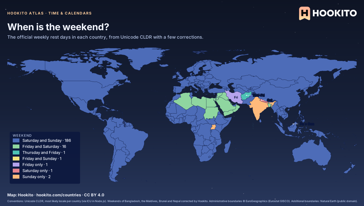
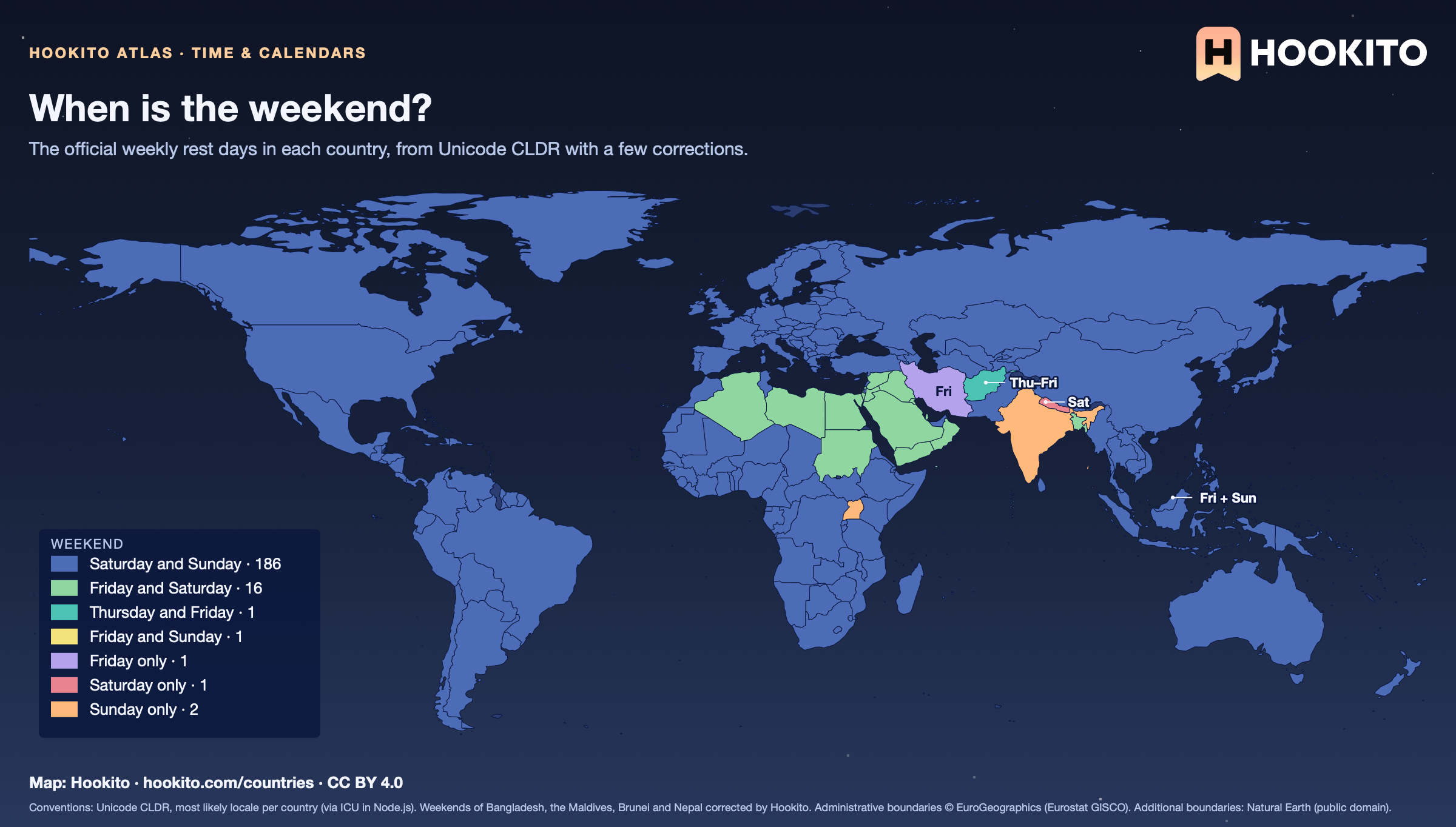
When is the weekend?

World map of weekend days: Saturday and Sunday in most of the world, Friday and Saturday across much of the Middle East and North Africa and in Bangladesh, Thursday and Friday in Afghanistan, Friday only in Iran, Sunday only in India and Uganda, Saturday only in Nepal, Friday and Sunday in Brunei.

Mostly CLDR’s weekend per country; Bangladesh, the Maldives, Brunei and Nepal are corrected by hand because CLDR leaves them at Saturday–Sunday. CLDR gives India and Uganda a Sunday-only weekend, though many offices there close on Saturdays too, and weekends vary within countries: some Malaysian states rest on Friday and Saturday.

Embed this map

Conventions: Unicode CLDR, most likely locale per country (via ICU in Node.js). Weekends of Bangladesh, the Maldives, Brunei and Nepal corrected by Hookito. Administrative boundaries © EuroGeographics (Eurostat GISCO). Additional boundaries: Natural Earth (public domain).

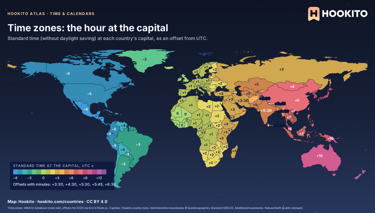
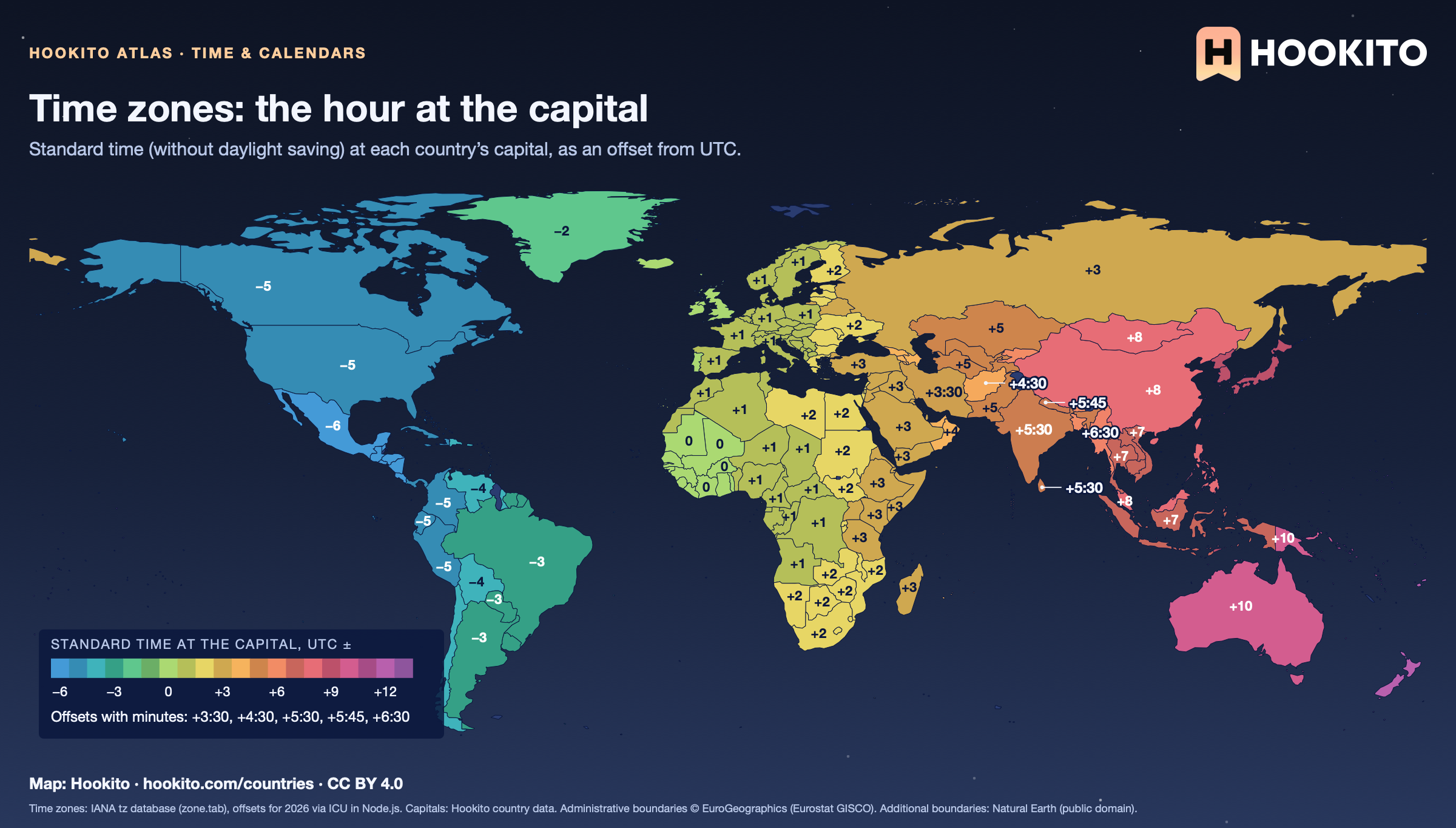
Time zones: the hour at the capital

World map of standard UTC offsets at each capital, from −10 in the Pacific through −5 on the US east coast, 0 in the UK and West Africa, +1 in most of Europe, +5:30 in India, +8 in China, to +12 and beyond in the Pacific; offsets with minutes such as +5:45 in Nepal and +3:30 in Iran are labelled.

Countries with several zones are coloured by their capital’s, so all of the United States shows Washington’s −5 and all of Russia Moscow’s +3; 18 countries here have more than one zone. Standard time is the smaller of the January and July 2026 offsets, so summer time is left out.

Embed this map

Time zones: IANA tz database (zone.tab), offsets for 2026 via ICU in Node.js. Capitals: Hookito country data. Administrative boundaries © EuroGeographics (Eurostat GISCO). Additional boundaries: Natural Earth (public domain).

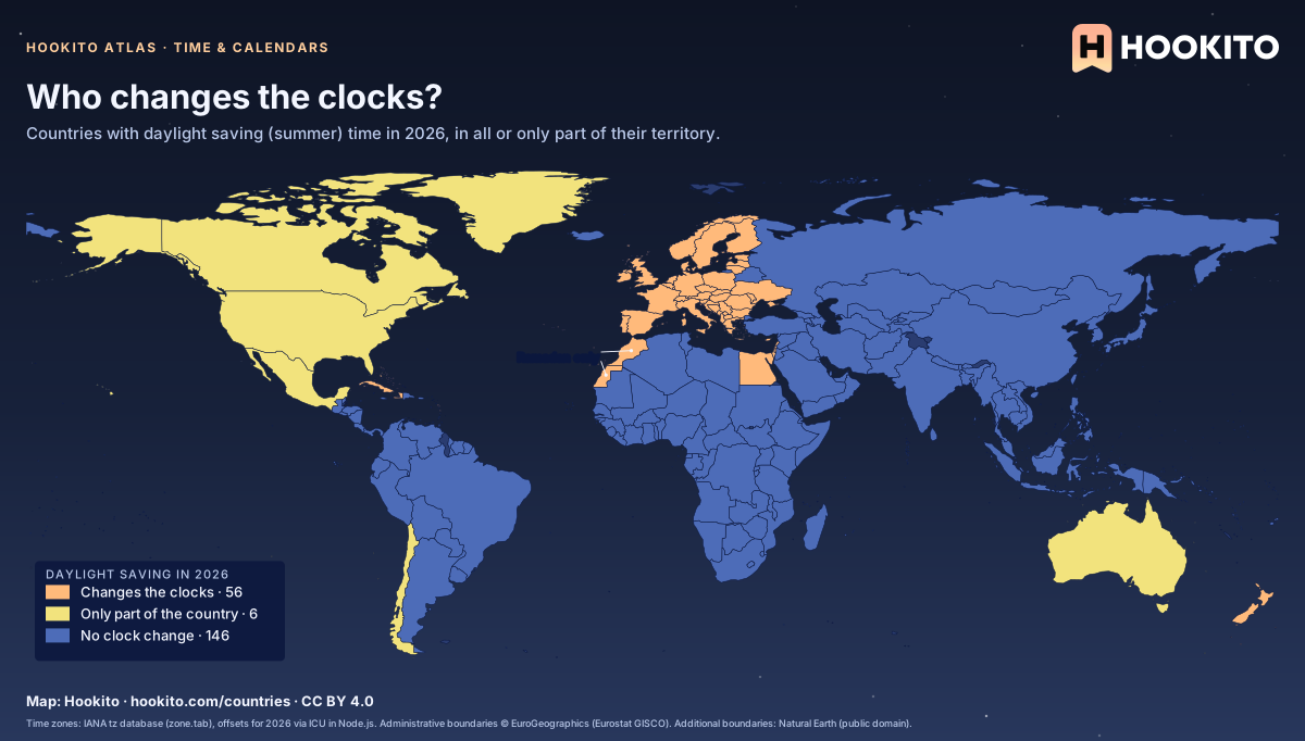
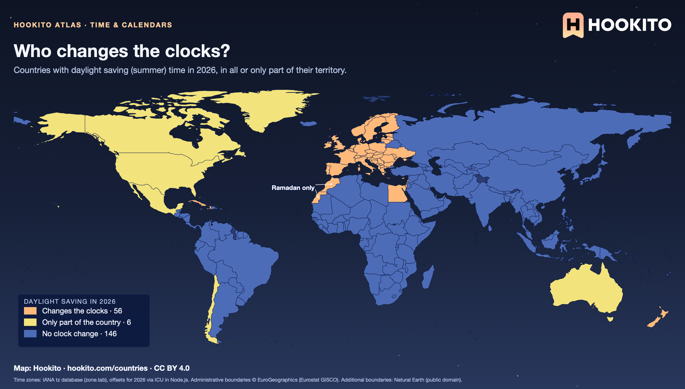
Who changes the clocks?

World map of daylight saving time in 2026: Europe, the United States, Canada, Chile, New Zealand, south-east Australia, Egypt, Lebanon, Israel and Cuba change their clocks; most of Africa, Asia and South America do not; the US, Canada, Australia, Mexico and Chile only in part.

A country counts if any of its tz zones has more than one offset during 2026. Only part changes in Australia, Canada, Chile, Greenland, Mexico and the United States: Arizona and Hawaii, Saskatchewan and Queensland stay on standard time, and Mexico keeps summer time only along the US border. Morocco and Western Sahara set the clocks back an hour during Ramadan instead of in winter.

Embed this map

Time zones: IANA tz database (zone.tab), offsets for 2026 via ICU in Node.js. Administrative boundaries © EuroGeographics (Eurostat GISCO). Additional boundaries: Natural Earth (public domain).

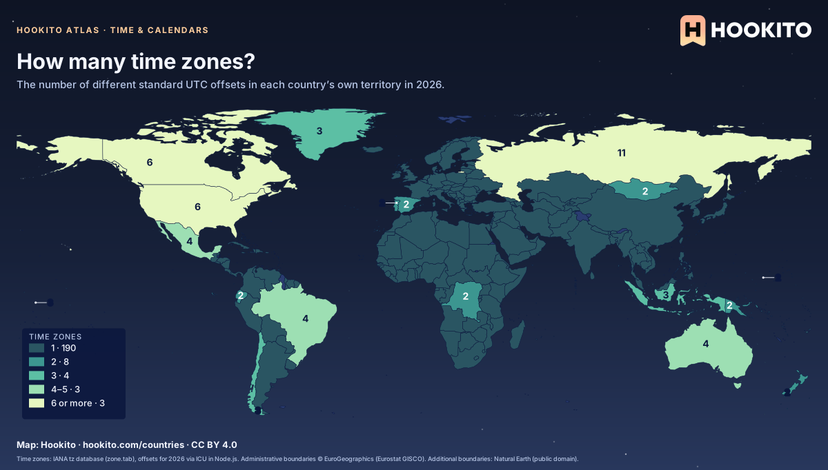
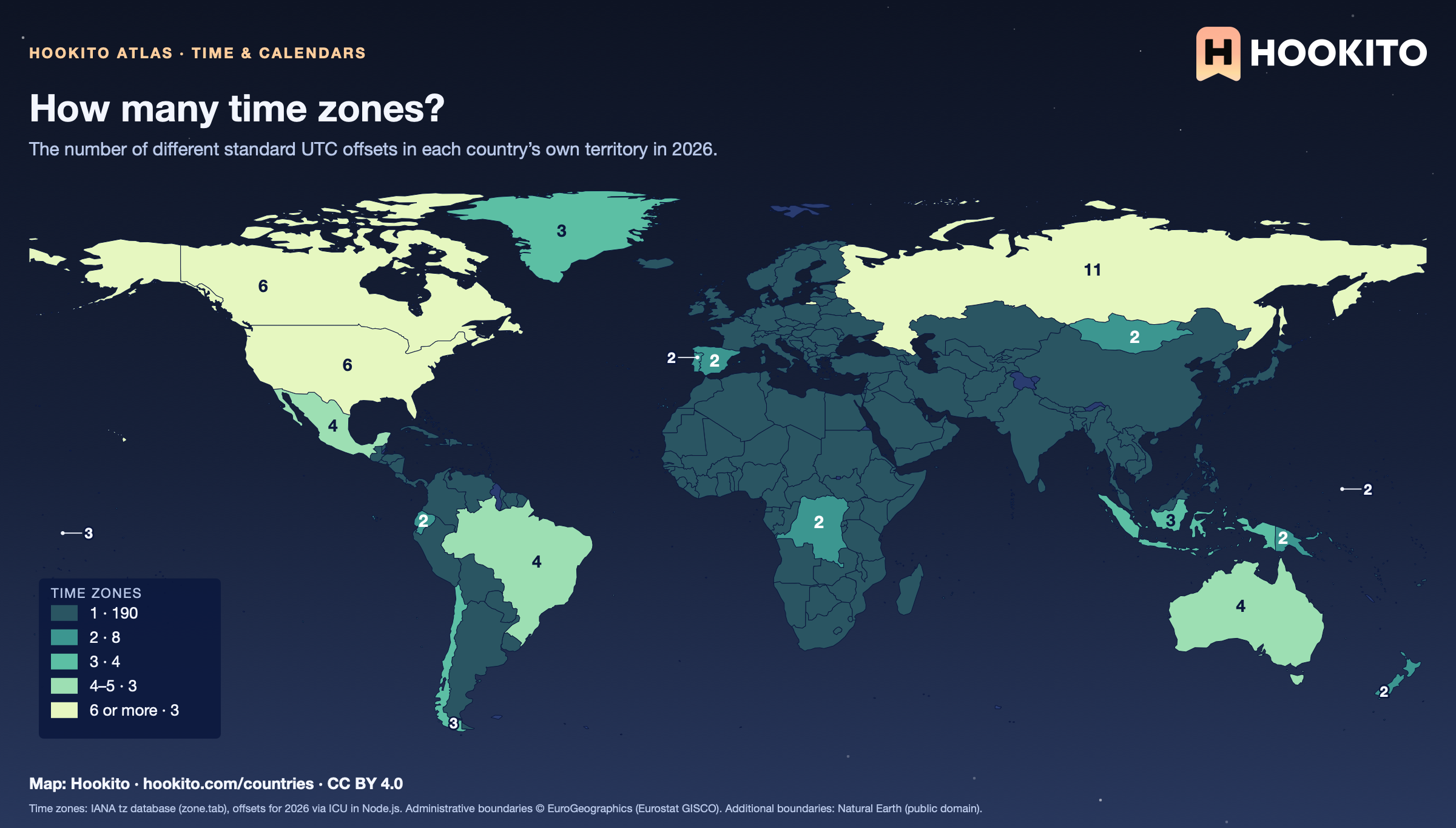
How many time zones?

World map of the number of time zones per country: Russia with 11, the United States and Canada with 6, Australia, Brazil and Mexico with 4, Indonesia, Chile and Kiribati with 3, a few with 2, and most countries with one.

Russia has 11, Canada and the United States 6 each. Overseas territories with their own country code are listed separately in the tz database, so France counts 1 here, though with its overseas regions it spans 12 zones, and the US count leaves out Puerto Rico and Guam. Unofficial zones (Xinjiang in China, Eucla in Australia) and Moscow time in occupied Crimea are not counted.

Embed this map

Time zones: IANA tz database (zone.tab), offsets for 2026 via ICU in Node.js. Administrative boundaries © EuroGeographics (Eurostat GISCO). Additional boundaries: Natural Earth (public domain).

Reusing the maps

You’re welcome to share, print or adapt these maps. The renderings are licensed CC BY 4.0: credit them as “Map: Hookito, hookito.com”, with a link to this page where you can.

The underlying data keeps its own terms, so keep its credits too. Administrative boundaries © EuroGeographics (Eurostat GISCO), which also applies to most country outlines. Additional boundaries are from Natural Earth (public domain). Each map lists its other sources: Wikidata and GeoNames for country facts, Our World in Data for the statistics, Unicode CLDR and the IANA time zone database for the calendar and clock maps, flag-icons (MIT) for the flags, Wikimedia Commons for the paintings, NASA Earth Observatory for the night imagery. The maps are offered as finished images only; the boundary data itself isn’t available for download here.

Where to next?

Back to the globe
Hookito landscape illustration